|
|
|||||||||
 County |
 City / Town |
 Directory |
 Maps |
 Contact Us |
 Advertise |
 Showcase |
 Calendar |
 Association |
 Passport |
Yuma County, straddling the 40th parallel on the Eastern edge of Colorado, was a relatively late addition to the Colorado map. While archeological digs in the county show that man has occupied the county since prehistoric times, the first "American" settlers didn't move into the county until after 1870. The first explorers, traveling through the area in a drought period, labeled the area the "Great American Desert." The Oregon Trail passed to the north following the Platte River. The Santa Fe Trail passed far to the south along the Arkansas River. The land along both rivers was settled early in Colorado history. The land between the two rivers remained a hunting ground used by several American Indian tribes.
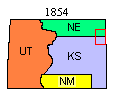
Originally claimed by Spain, what is now Yuma County was part of the land the young United States acquired from France in the 1803 Louisiana Purchase. In 1805, it was included in the new Louisiana Territory. It was part of the original 1812 Missouri Territory and was designated unorganized US territory in 1821 when Missouri became a State. The 1854 Kansas-Nebraska Act, split what is now Yuma County between Nebraska Territory and Kansas Territory along the 40th parallel. (Today's Yuma County border is shown in red on this and the following maps.)
The discovery of gold in the Colorado Rockies in 1858 brought an influx of people to Colorado but the high plains remained an Indian hunting ground until about 1870. Conflicts between the new residents spreading out from the Front Range, travelers on the trails to the mountains and the Indians eventually lead the US Army and the Colorado Militia to force the tribes out of Eastern Colorado.
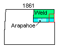
Colorado Territory was created by Congress in 1861. Northeastern Colorado was split between Weld and Arapahoe Counties along the 40th parallel. What is now Yuma County was split in half; Weld County to the north and Arapahoe County to the south. Both counties stretched from Denver to the Kansas-Nebraska border. The land in eastern Colorado remained mostly unoccupied. (To keep from confusing you, only northeast Colorado counties are reflected on this map and the maps that follow.)
After the Civil War, settlement in Western Kansas forced Texas cattle herds driven north to market further and further west. About 1870, cattle trails were established through Eastern Colorado to the Union Pacific railroad at Ogallala, Nebraska and to markets further north in South Dakota, Wyoming and Montana. Ranchers recognizing the value of the high plains grasslands established holding and fattening areas in what is now Yuma County that developed into large ranches occupying both private and public lands. Ranching was still the only real industry in the area when Colorado became a state in 1876.
The Burlington and Missouri (later the Chicago, Burlington and Quincy) railroad completed a mainline to Denver in 1882 through the middle of what would become Yuma County. Land and town sites along the new rail line were promoted and sold to settlers to finance the construction and establish a base of customers for the new line. Then in 1885, President Cleveland forced the large ranches off public lands and opened it to homesteaders. Real Yuma County settlement dates from those two events.
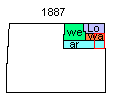
By 1887, the population of eastern Weld County was large enough for voters to demand a split into new counties. The original Weld County was split roughly in half. The southeastern corner became Washington County with the county seat designated as Akron. The northeastern corner became Logan County with the county seat designated as Sterling.
Two years later in 1889, Washington County was divided in half and Yuma County [shown in red] was created with the County seat in Yuma, named after the Yuma Indian tribe (supposedly for a Indian railroad section hand buried along the B&M track near what would become the Yuma town site). The southern portion of the todays' Yuma County remained in Arapahoe County. At the same time, Logan County was divided in half to create Sedgwick [red] and Phillips [green] Counties. Morgan County [dark green] was formed from the southeast corner of Weld County.
Arapahoe County remained stretching from Denver to the Kansas border. The Colorado Legislature divided Arapahoe County east to west in 1901 to form Adams County [violet]. The new Adams County was just as wide as Arapahoe County and voters in the eastern part both counties objected to having to travel so far to the county seats located in Denver and Brighton.
In 1902, Yuma County voters, in what is still a highly debated election, decided to move the Yuma County seat to Wray. Some Wray residents packed the County's records in the middle of the night and moved them to Wray. Yuma citizens had wanted to hold on to them until after the election results were disputed in court.
In 1903, the City and County of Denver was approved and Arapahoe and Adams Counties were reorganized. The eastern portions of both of the 1901 Adams and Arapahoe Counties were added to Washington and Yuma Counties, doubling their area. The 1903 changes finalized the county borders of today's northeastern Colorado map.
Yuma County today remains true to its heritage. It is primarily agricultural. Land use is divided almost evenly between ranching and farming. It measures 60 miles north to south and 40 miles east to west. The 1990 population was 8954 down from the 1920 census high of 13,897.